Eta Could Be Major Hurricane at Landfall in Central America
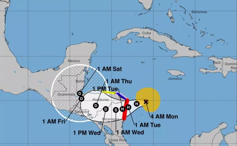
The 2020 Atlantic Hurricane Season is officially into its last scheduled month. We hope the tropical cyclones know that they will no longer be welcomed after November 30th when the season ends. Somehow, I don't think they care but I think we should be caring about what happens with Hurricane Eta. The storm reached that status earlier this morning and is continuing on a due west track that will now bring the system onshore late in the day on Tuesday.
Hurricane Eta was located at the 0400CST advisory about 150 miles east of the Nicaraguan border with Honduras. Based on track timing and forward speed the system should make landfall just south of that border in Nicaragua by Tuesday afternoon or very early Wednesday morning.
Forecasters with the National Hurricane Center believe the system will undergo a rapid intensification cycle and by this time tomorrow be producing sustained winds in excess of 110 miles per hour as it nears the coastline. Another aspect of Hurricane Eta that we can't discount is the fact that this system is moving very slowly.
In fact, the system should remain in the same general part of the world, over Nicaragua and Honduras, from late Tuesday all the way through Friday. Rainfall amounts measured in feet will not be uncommon over the watch and warned area. Then, we'll have to deal with what might come next.
Some of the long-range tropical model guidance is suggesting that Eta will survive its landfall with at least some kind of circulation intact. Should that happen, the system could move out over the warm waters of the Caribbean and strengthen again.
Remember last week when we told you something was brewing in or around the Gulf in early November? Well, this would be it, that is if the system does in fact hold together over Central America. Let's hope that it won't and if it does it will stay out to sea and not bother anyone, especially in Louisiana anytime soon.
10 Handy Home Remedies to Take the Itch Out of Mosquito Bites
More From Hot 107.9


