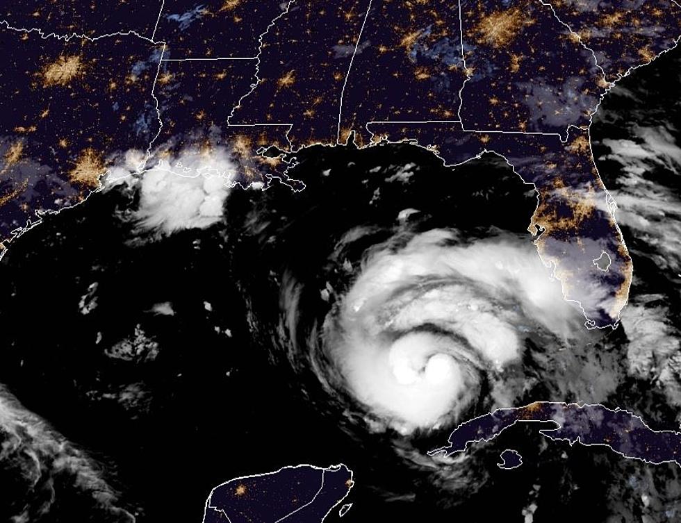
Hurricane Ida – 7 AM Update, Forecast, and Track Projection
Updated 0700 CDT August 28, 2021: The National Hurricane Center has issued its intermediate advisory on Hurricane Ida. The storm is reported to have maximum sustained winds of 85 mph. The 0700 CDT advisory had the storm centered about 385 south southeast of the mouth of the Mississippi River. That's about 440 miles south southeast of New Orleans.
Ida was moving to the northwest at 16 mph. The path and speed are expected to remain fairly constant for the next several hours. Forecasters say hurricane-force winds extend outward 25 miles from the center of circulation. Tropical-storm-force winds extend outward from the center 115 miles.
As Ida strengthens, as it is forecast to do, that wind field will increase as well. However, the worst conditions will be felt mainly at the center and to the east of the center. Landfall is still projected along coastal Louisiana late Sunday afternoon or early evening.
(From 0400 August 28,2021) Forecasters with the National Hurricane Center continue to monitor the progress of Hurricane Ida. The storm, as of the 0400 am advisory, was centered about 510 miles southeast of New Orleans Louisiana. Ida was moving to the northwest at 15 mph. The maximum sustained winds were 80 mph.
The forecast does suggest that Ida will continue to strengthen as it moves over the very warm waters of the southeastern Gulf of Mexico. Forecasters believe those warm waters combined with environmental conditions over the Gulf will lead to the rapid intensification of the system.
The current intensity forecast from the Hurricane Center suggests that Ida will make landfall along Louisiana's southern coast as a Category 4 Hurricane. Hurricane warnings remain in effect for the Louisiana coastline from Intracoastal City to the mouth of the Pearl River.
The official forecast track from the Hurricane Center suggests that landfall will likely occur late Sunday afternoon or early evening. As of now, the predicted landfall will be somewhere between Morgan City in St. Mary Parish and Houma in Terrebonne Parish.
Following landfall, the center of circulation is then expected to move in a more northerly direction, this would bring the storm's center very near Baton Rouge by just after midnight Monday morning.
Once over land, the storm system is expected to weaken rapidly. Forecasters believe the storm will drop from Category 4 at landfall to a Category 2 storm as it crosses I-10 near Baton Rouge early Monday morning. The storm is expected to continue on a northerly path into southwestern Mississippi where it should weaken to a tropical storm by midday Monday.
If the current forecast track holds this will keep most of Acadiana on the western side of the storm's circulation. However, St. Mary Parish, Iberia Parish, and St. Martin Parish could be very close to the storm's center.
Our news partner, KATC Television has prepared this graphic the quickly explains the potential impacts of the storm across Acadiana. It is important to note, that a shift in the track of 20 or 30 miles would make a big difference in the kind of conditions you might see. Dave Baker has written an outstanding explanation of the current thinking on where the storm might go and when its conditions might be felt across the area.
A shift further to the west would bring stronger winds and heavier rain into the heart of Acadiana. A shift further to the east might lessen those impacts significantly. Therefore, today is your day to finalize your storm preparation. It is also suggested that if you do plan on evacuating that you act on that decision by this evening.
The thinking as of this morning is that the eastern half of Acadiana, namely from Lafayette east will likely experience sustained hurricane-force winds during the passage of the storm. Meanwhile, in Lafayette, Vermilion, and St. Landry Parishes there will likely be wind gusts reaching hurricane force but the sustained winds will be of tropical storm force.
Rainfall will certainly be another major impact of Hurricane Ida. Again the heaviest rainfall will occur at the center of the storm's circulation and to the east. Rainfall amounts of a foot or more will be quite common in those areas.
Rainfall rates to the west of the storm's center will likely be less. However, rainfall totals of four to eight inches in Lafayette, Vermilion, and St. Landry parishes will be common.
The next intermediate advisory from the Hurricane Center will come at 0700 am. The next full update will be distributed at 1000 am. Remember to download our station app and activate your Breaking News and Breaking Weather Alerts for the late-breaking news and information instantly.
15 Essential Items for Your Hurricane Kit
More From Hot 107.9


