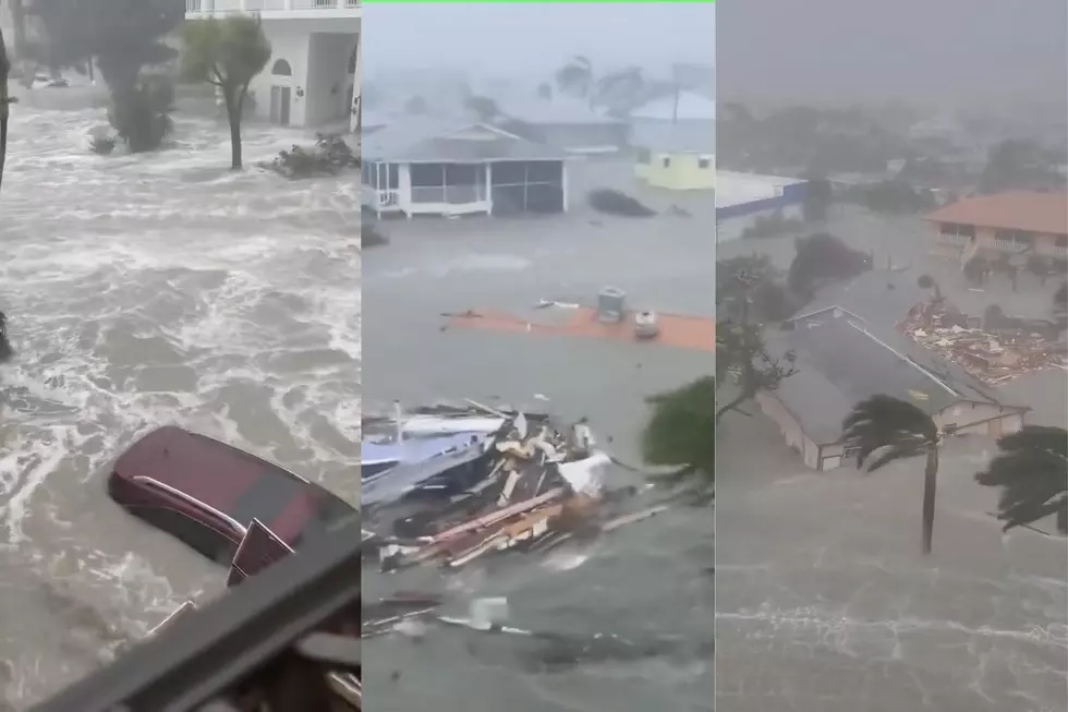
Ian Strengthens, Second US Landfall Likely Later Today
Once major Hurricane Ian has once again attained hurricane status. Forecasters with the National Hurricane Center say the storm once again crossed the threshold to become a hurricane late yesterday after the center of circulation exited the Florida peninsula and was situated over the warm waters of the Atlantic Ocean just east of Jacksonville.
As of early this morning, Ian was reported to have maximum sustained winds of 85 mph. The storm was centered about 150 miles south of Charleston South Carolina. The system is expected to make a second US landfall on the South Carolina coast.
Forecasters say the forward speed and direction of the storm, 10 mph toward the north northeast, should carry the center of circulation across the coast sometime later this afternoon. A hurricane warning has been posted from the Savannah River at the Georgia South Carolina Border to Cape Fear in North Carolina.
Satellite images from the National Weather Service suggest that most of the stronger storms, higher winds, and heavier rain showers are on the western side of the storm's center. This would mean the worst of Ian 2.0 would be on the coastal side of the storm as it makes landfall.
So far damage estimates from Ian's path of destruction over Cuba and Florida are in the billions of dollars. One disaster modeller suggests the once Category 4 storm could result in over $67 billion dollars in damages in Florida alone. The storm's impact could also affect prices for orange juice and other citrus products for US consumers in the coming months and even years, depending on how much of Florida's citrus crop was damaged or destroyed.
Elsewhere in the tropics, the tropical Atlantic Basin has calmed down considerably from last week when there were four active cyclones. Besides Ian, the only other trouble spot forecasters are monitoring is a tropical wave that has emerged off the coast of Africa. Forecasters have given this wave a 50% chance of strengthening over the next five days.
In South Louisiana, we are still in what is known as "Louisiana Prime Time" as far as tropical weather goes. The peak of the tropical season is September 10th but there is also a mini peak, if you will, on the downside of that peak that usually happens in early to mid-October.
However, tropical activity usually declines rapidly after this secondary peak, although we still can't rule out any tropical storm formation until the season officially ends on November 30th. Even then, if Mother Nature wants to fire up another storm after the season is over, there really isn't much we can do about it, can we?
If you'd like to help victims of Hurricane Ian, here's how you can do that. You can expect official updates from the National Hurricane Center at 4 am, 10 am, 4 pm and 10 pm (Central Time) with intermediate advisories at 7 am, 1 pm, 7 pm, and 1 am Saturday morning.
Startling Images of Hurricane Ida Aftermath
Gallery Credit: Michael Dot Scott
More From Hot 107.9