Three Tropical Systems Now Being Watched for Development
Last week we told you that this week and the days leading up to the peak of the Hurricane Season were going to get really busy in the tropics. We explained the weather phenomenon that is a likely catalyst for this increased tropical activity.
What we didn't expect was for the tropics to figuratively explode with activity as a result of these weather conditions. But it sure looks as if Mother Nature is about to put on a show and it's not the kind of show anyone wants front row seats for.
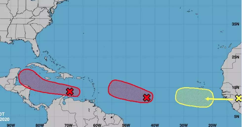
Let's work backward across the Atlantic starting with the weather system that is furthest away. That honor would go to a tropical wave that has yet to exit the African continent. That wave should roll off the shore and into the ocean over the next few days. Right now the forecast for intensification is minimal.
The second furthest tropical wave has been designated by the National Hurricane Center as Invest 98L. The Hurricane Center is giving that system a 90% probability of becoming a tropical cyclone over the next 48 hours. In fact, depending on when you read this article, that could have already happened.
Track guidance from the Hurricane Center mirrors the tropical model guidance. Most of the models agree this system will shoot across the Atlantic and encounter the outermost islands of the Caribbean Sea over the next few days. The storm appears to be headed for South Florida, at least at this juncture. Although we could see the system slide into the Gulf of Mexico sometime next week.
The system that is of more immediate concern is a tropical wave that has been labeled Invest 97L by the Hurricane Center. This system located very near the northern coast of Venezuela has been given an 80% probability of strengthening into a tropical cyclone over the next five days.
Track guidance from the Hurricane Center brings this system very close to the Yucatan Peninsula by this weekend. From there the tropical model guidance is all over the map, literally. Some models pull the system into South Texas, other models bring the system into the middle of the Gulf of Mexico south of the Louisiana coastline, while others turn the storm in a more northerly direction toward the Florida panhandle.
About all, we can do at this juncture is wait and see. The forecast tracks for all of these systems will undoubtedly change over the next week or ten days. Whether those changes include a tropical encounter for Louisiana we'll just have to bide our time. In the meantime, we can get ourselves ready for a storm. Hopefully, we won't need to act on those preparations but better safe than sorry, right?
Ten Beach Hacks For Summer
More From Hot 107.9