Warnings Posted Ahead of Developing System in Gulf of Mexico
This would not be the week you'd want to be working on an offshore oil platform in the Bay of Campeche. The rigs that populate the southern shores of the Gulf of Mexico and the residents who live along that coastline will be treated to several days of tropical downpours, gusty winds, and high surf as Tropical Depression 3 is forecast to basically sit still over that area until later this week.
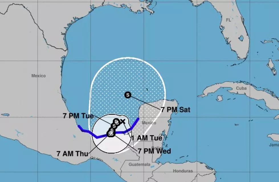
As of early this morning, the system was still a tropical depression by definition but satellite images and ground reports suggest the system is getting stronger. Forecasters with the National Hurricane Center expect the system to become Tropical Storm Cristobal by the end of the day. Therefore tropical storm warnings have been posted for much of the Gulf Coast of Mexico.
Tropical forecast models suggest the system will be a slow mover. That means rainfall totals along and near the Mexican coast could reach several inches before the system begins to move away from the area later this week.
Those same tropical forecast models do suggest the system will move northward out of the Bay of Campeche and into the open waters of the Gulf of Mexico by Saturday. Many of those track models do suggest that the system will track toward Louisiana. However, the consensus of which part of the state will likely be most affected by the storm is unclear at this time.
We do have several days to watch and prepare for this storm. Now is the time you'll want to double-check your preliminary hurricane checklist. You'll also want to be developing your game plan for later in the week or early next week when the system could be playing a larger part in our forecast plans.
Guess Louisiana Cities From Space
More From Hot 107.9